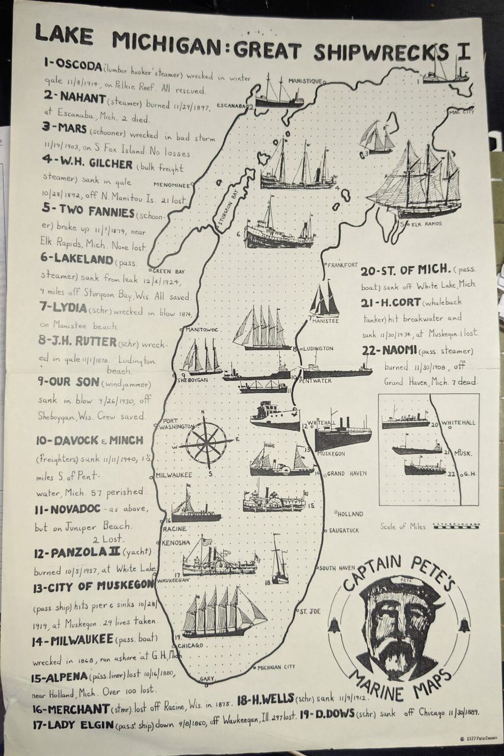
A Closer Look at the Illustration
Titled “Lake Michigan: Great Shipwrecks I,” this detailed marine map captures some of the most tragic shipwrecks in Lake Michigan history. The artwork appears to be signed by Pete Cassar, though the signature is hard to read. If you knew him or can confirm the correct name, feel free to comment and let us know more about the artist. The map blends hand-drawn ships, coastal outlines, and short descriptions to highlight 22 major shipwrecks across the lake’s shoreline.
Ship Names, Dates, and Disasters
Each shipwreck is labeled with a number and a short note describing what happened. The (1) Oscoda wrecked in 1914 during a winter gale, but all crew members survived. However, others like the (17) Lady Elgin sank with great tragedy—297 people were lost near Waukegan in 1860. Fires, storms, and sudden sinkings claimed many ships such as the (2) Nahant, (10) Davock, (10) Minch, (13) City of Muskegon, and (14) Milwaukee. Each numbered entry paints a picture of danger and survival on the Great Lakes.
Other tragedies include the (4) W.H. Gilcher, lost in a gale near North Manitou Island with 21 lives taken, and the (20) St. of Mich., a passenger boat that sank off White Lake. The (11) Novadoc, (6) Lakeland, (3) Mars, and (8) J.H. Rutter are just a few more that mark how unpredictable the waters once were.
Artwork That Brings History to Life
Dozens of hand-drawn ships—including schooners, steamers, yachts, and tankers—fill the map. Each vessel is placed along the part of the coast where the disaster occurred. From Muskegon and Whitehall to Chicago and Racine, the map gives you a sense of the size and spread of these tragedies. The dotted background and labeled towns give it a classic maritime chart feel, while a bold sketch of “Captain Pete” decorates the lower corner with personality and charm.
Why the Map Still Matters
Even today, this artwork tells stories that history books may forget. These shipwrecks reflect the power of the lake and the bravery of those who traveled it. While most people only see Lake Michigan as a place to swim or fish, this map shows the danger it once held. If you’ve seen this map before or know stories behind it, share your memories—we’d love to hear what you know.